Starting Point: Rotterdam Centraal Station Total Estimated Walking Time: Approximately 3 and a half hours (excluding extensive stops inside buildings or long coffee breaks). Wear comfortable shoes!
Part 1: The New Gateway & Early Reconstruction (1 hour)
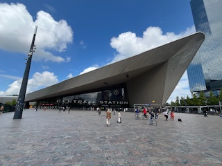
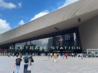
- Rotterdam Centraal Station (Start: 0:00)
- Architecture & Real Estate: Completed in 2014, this station is a striking example of contemporary architecture by Benthem Crouwel Architects, MVSA Architects, and West 8. Its most iconic feature is the vast, pointed stainless steel roof that directs visitors towards the city centre. It replaced the previous station, which was destroyed in WWII. It’s a key transport hub and a symbol of Rotterdam’s modern identity and ambition.
- Cultural Context: This station serves as a modern gateway to a modern city, reflecting Rotterdam’s innovative spirit from the moment you arrive.
- Directions from arrival: Take a few moments outside the main entrance (facing the city center) to admire the station’s striking design.
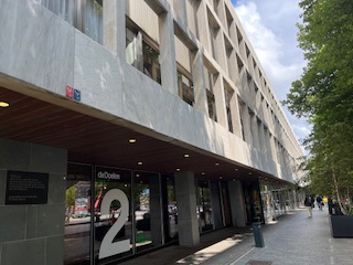
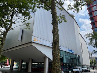
- De Doelen Concert Hall & Schouwburgplein (approx. 5 minutes walk from Centraal Station) (0:15)
- Directions:
- From the station entrance, walk straight down the broad avenue called Weena.
- Cross the large intersection. Continue straight and look for Schouwburgplein (Theatre Square) on your right. De Doelen is the large building complex on this square.
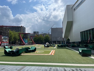
- Architecture & Real Estate: De Doelen (1966) is a prime example of post-war modernist architecture, designed by Kraaijvanger Architects. Its robust concrete facade and functional design reflect the era’s focus on reconstruction and efficiency. Schouwburgplein itself is a dynamic urban space with hydraulically controlled light poles, demonstrating innovative public space design.
- Cultural Context: This area represents the cultural heart of the reconstructed city, aiming to revitalize public life after the war.
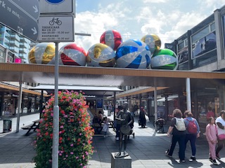
- Lijnbaan (approx. 5 minutes walk from De Doelen) (0:35)
-
- Directions:
- From Schouwburgplein, walk south (away from Centraal Station) onto Karel Doormanstraat.
- Turn right onto Lijnbaan.
- Architecture & Real Estate: Opened in 1953, the Lijnbaan was Europe’s first purpose-built pedestrian shopping street. Designed by Broek & Bakema, it’s characterised by its uniform rows of single-story shops, covered walkways, and integrated green spaces. It was an ambitious urban planning experiment, demonstrating a new approach to retail architecture and public space.
- The Lijnbaan is the main shopping street of Rotterdam. It was opened in 1953, as the main pedestrian street in the new shopping district, after the old shopping district was completely destroyed during the bombing of Rotterdam by the German Luftwaffe.
- Cultural Context: The Lijnbaan was a revolutionary concept, designed to bring people back to the city centre and offer a modern, efficient shopping experience. It’s a significant landmark in post-war urban planning history.
- Directions:
Part 2: Heart of the Reconstruction & Iconic Modernism (1 hour 15 minutes)
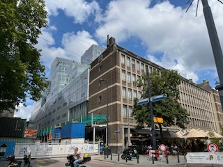
- Timmerhuis (approx. 5 minutes walk from Lijnbaan) (1:00)
- Directions:
- From Lijnbaan, head east towards Coolsingel (the major boulevard).
- You’ll see the Timmerhuis across Coolsingel. Cross Coolsingel safely, perhaps using the tunnel under it or a pedestrian crossing.
- The Timmerhuis is located at Rodezand 34.
- Architecture & Real Estate: Designed by OMA (Office for Metropolitan Architecture) and completed in 2015, the Timmerhuis is a striking mixed-use building resembling a pixelated cloud. It houses municipal offices, residential apartments, and a museum (Rotterdam Museum). Its modular design allows for flexibility and light penetration, making it a key example of contemporary architectural thought in Rotterdam.
- Cultural Context: It represents a new era of urban development, combining public and private functions in a highly innovative structure, standing as a modern icon next to a historical landmark.
- Directions:
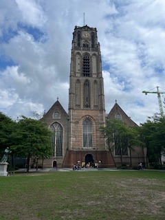
- Laurenskerk (St. Laurens Church) (approx. 2 minutes walk from Timmerhuis) (1:20)
- Directions:
- The Laurenskerk is directly adjacent to the Timmerhuis.
- Architecture & Real Estate: This late-Gothic church (15th century) is one of the few buildings in Rotterdam’s city centre that survived the 1940 bombing, though heavily damaged. It was meticulously restored. Its brickwork and towering presence offer a stark contrast to the surrounding modern architecture, serving as a powerful reminder of the city’s past.
- Cultural Context: It stands as a symbol of resilience and the historical anchor of the city, a testament to what Rotterdam was before its radical transformation.
- Directions:
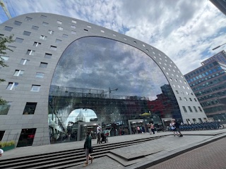
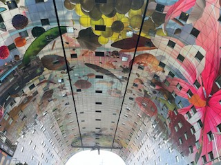
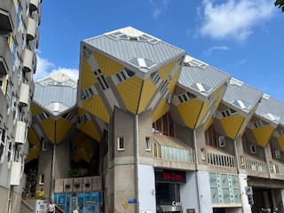
- Markthal (Market Hall) & Cube Houses (Kubuswoningen) (approx. 5 minutes walk from Laurenskerk) (1:35)
- Directions:
- From Laurenskerk, walk east past its southern side. You will immediately see the striking arch of the Markthal.
- The Cube Houses are located right next to the Markthal, accessible from the Blaak side.
- Architecture & Real Estate:
- Markthal: Completed in 2014, designed by MVRDV, this is a revolutionary combination of a fresh food market, apartments, and a car park, all under a spectacular arch. Its vibrant, colourful interior ceiling (Horn of Plenty by Arno Coenen and Iris Roskam) and its integrated residential units make it a unique and highly successful mixed-use development.
- Cube Houses: Designed by Piet Blom and built in the early 1980s, these yellow tilted cubes on hexagonal pylons are one of Rotterdam’s most famous architectural features. They are residential properties, with one “show cube” (Kijk-Kubus) open to the public for a small fee. They represent an experimental approach to urban living and design.
- Cultural Context: These buildings exemplify Rotterdam’s playful, innovative, and sometimes audacious approach to architecture and urban living, pushing boundaries for both public and private spaces.
- Directions:
Part 3: The New Manhattan & Waterfront Development (45 minutes)
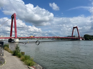
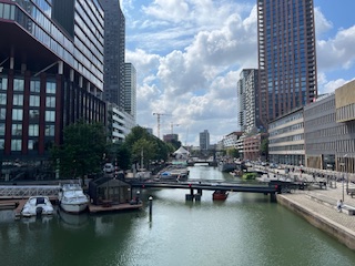
- Blaak Station & Willemsbrug (approx. 5 minutes walk from Cube Houses) (2:15)
- Directions:
- From the Cube Houses/Markthal, you are already at Blaak Station, a prominent transport hub with unique architectural elements itself.
- Walk directly east from the Cube Houses along the overpass/street. You will quickly arrive at the Willemsbrug (Willem Bridge), the bright red cable-stayed bridge.
- Architecture & Real Estate: Blaak Station’s distinctive glass structure provides a modern gateway to this area. The Willemsbrug, a striking red landmark, connects the city centre to the South Bank. It symbolises Rotterdam’s connection across the Maas River, enabling the development of the Kop van Zuid.
- Directions:
- Kop van Zuid / Wilhelminapier & De Rotterdam (approx. 15 minutes walk over Willemsbrug) (2:25)
- Directions:
- Walk across the Willemsbrug to the south side of the Maas River.
- Once you’ve crossed, you are on Wilhelminapier in the Kop van Zuid district.
- Turn right and walk along the pier. You’ll immediately be immersed in a landscape of modern high-rise architecture.
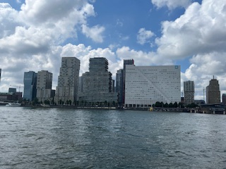
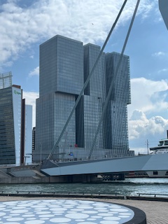
- De Rotterdam (by OMA, completed 2013) is impossible to miss – it’s the massive, stacked vertical city complex often called the “vertical city,” comprising three interconnected towers for offices, apartments, and a hotel. It’s located prominently on the pier.
- Architecture & Real Estate: This entire area, often called “Manhattan on the Maas,” is a showcase of contemporary high-rise real estate. Besides De Rotterdam, look for other notable buildings like the New Orleans (residential tower with a jazz museum), the Montevideo (another residential tower with a distinctive weathercock), and the Maastoren (Netherlands’ tallest building for a time). This area represents the pinnacle of modern, mixed-use urban development in Rotterdam, transforming a former port area into a vibrant metropolitan district. Take the opportunity to walk through the residential areas and see the similarity to housing in Amsterdam.
- Cultural Context: Kop van Zuid is a testament to Rotterdam’s ambition to be a leading global city, attracting investment and fostering high-density, high-quality urban living and working.
- Directions:
- Erasmusbrug (Erasmus Bridge) (approx. 10 minutes walk along the pier) (2:50)
- Directions:
- Walk west along Wilhelminapier towards the large white cable-stayed bridge.
- Architecture & Real Estate: Designed by Ben van Berkel and completed in 1996, the Erasmusbrug is Rotterdam’s most iconic bridge, nicknamed “The Swan” due to its elegant pylon. It’s a marvel of civil engineering and a beautiful piece of urban architecture, connecting Kop van Zuid back to the city centre. It was instrumental in enabling the large-scale development of Kop van Zuid.
- Cultural Context: More than just a bridge, it’s a symbol of modern Rotterdam, linking its past (via the city centre side) with its future (via Kop van Zuid).
- Directions:
Concluding the Walk (3:00):
- From the Erasmusbrug on the Kop van Zuid side, you can either:
- Walk back across the Erasmusbrug to the city centre.
- Find the Wilhelminaplein Metro Station (located at the base of the Erasmusbrug on Kop van Zuid) to take the metro back to Rotterdam Centraal Station or your next destination. It is about a 30-minute walk back. Why not stop at the Old Port for refreshments and to compare notes!