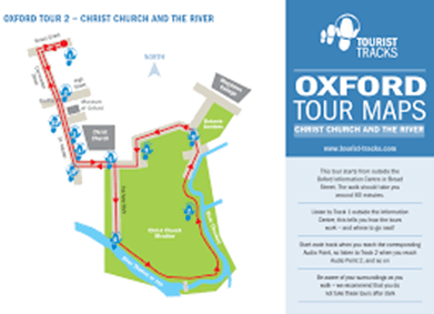
The Tour
- Start at Headington Campus.
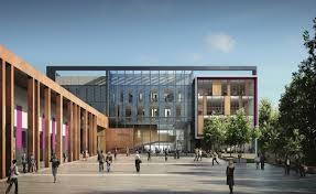
Please meet your Module Leader or Course supervisor outside the main entrance to the John Henry Brookes building as directed. You will be allocated into a group of no more than 6 people. Non-attendance or turning up outside this allocated time may lead to a zero result being awarded
2. Walk South towards the City Centre and St Clements.
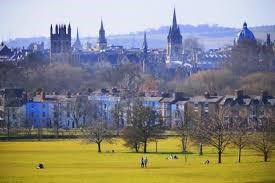
In your group. proceed towards Oxford City Centre turning left outside the campus, carefully crossing the busy A420 London Road to walk past Headington Hill Campus on your right and down Headington Hill. After about 5 minutes you will see South Park on your left.
At the bottom of the hill you will enter the area of St Clements
3.The Plain
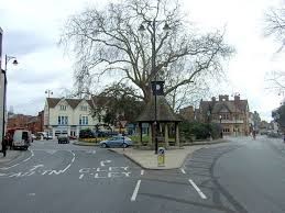
At St Clements/ The Plain roundabout, home of the Cape of good Hope public house, follow the directions towards the City Centre crossing Magdalen bridge and then immediately cross the road to turn left down Rose Lane with Oxford Botanical gardens on your left.
4.Oxford Botanical Gardens
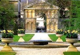
The University of Oxford Botanic Garden is the oldest botanic garden in Great Britain and one of the oldest scientific gardens in the world. The garden was founded in 1621 as a physic garden growing plants for medicinal research. Today it contains over 5,000 different plant species on 1.8 ha (4 1⁄2 acres). It is one of the most diverse yet compact collections of plants in the world and includes representatives from over 90% of the higher plant families.
Proceed through the gate at the end of the Rose Lane and continue straight onto Christ College, Broad Walk
5.Broadwalk
Turn right to follow the Broad Walk with Christ College, part of Oxford University on your right until you reach St Aldates.
When you have more time , you could explore the Christchurch meadow walk which is very picturesque and a round loop can incorporate the Cherwell boat house, Christ church meadow, and Broad walk taking in wonderful views alongside the River Cherwell.
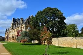
Founded in 1546 by King Henry VIII, Christ College is one of the larger colleges of the University of Oxford] It is also the wealthiest college with an endowment of £577.6m as of 2019. Christ Church has a number of architecturally significant buildings including Tom Tower (designed by Sir Christopher Wren), Tom Quad (the largest quadrangle in Oxford), and the Great Dining Hall which was also the seat of the parliament assembled by King Charles I during the English Civil War. The buildings have inspired replicas throughout the world in addition to being featured in films such as Harry Potter and The Golden Compass. This has helped Christ Church become the most popular Oxford college for tourists with almost half a million visitors annually.
Christ Church has many notable alumni including thirteen British prime ministers (more than any other Oxbridge college), King Edward VII, King William II of the Netherlands, seventeen Archbishops, writers Lewis Carroll (Alice in Wonderland) and W. H. Auden, philosopher John Locke, and scientist Robert Hooke. Christ Church is also partly responsible for the creation of University College Reading, which later gained its own Royal Charter and became the University of Reading.
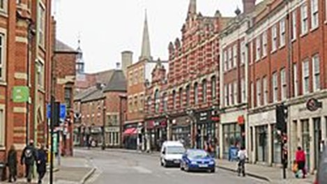
St Aldate’s is a street in central Oxford, England, named after Saint Aldate, but formerly known as Fish Street. The street runs south from the generally acknowledged centre of Oxford at Carfax. The Town Hall, which includes the Museum of Oxford, is on the east side of the street
6.Turn left onto St Algates then turn right up Speedwell Street into Norfolk Street, Castle Street, passing County Hall on your left and then onto New Road
7.Turn left off New road enter the Castle Quarter.
The Heritage at the Heart of the University City of Oxford is Oxford Castle Quarter. Its history spans ten centuries, beginning even before the Norman Baron Robert D’Oiley built St George’s Tower and the Mound in 1071.
The site has served time as a Royal Castle, from which the City and upper reaches of the Thames Valley were administered, as a centre of justice, and for several hundred years – a Gaol – hidden from the public view behind impenetrable 5 metre high stone walls. This remarkable place has now become Oxford’s Oldest New Quarter. The historic buildings have been restored and appropriate architectural additions have been made. A truly urban environment has emerged, with new and easy public access on all sides to reveal a host of exciting surprises.
Apart from the abiding Heritage of the site, it offers many other facilities. Accommodation is provided in 40 unique apartments and, for the shorter-term guests, Malmaison Hotel is crafted within the prison walls – a charismatic place to stay with the famed Malmaison-style interpreted in unique buildings
8.Return onto New Road turning left and proceed west down Park End Street onto Frideswide Square
Frideswide Square is a square to the west of central Oxford. The square is named after the patron saint of Oxford, St Frideswide.
The “square” is triangular. Immediately to the north, the modern Saïd Business School of Oxford University dominates the square, established in 1996 on the site of the former Oxford Rewley Road railway station. To the east are Hythe Bridge Street (A4144) and Park End Street, both leading into central Oxford. Between them is the Royal Oxford Hotel. To the south, Hollybush Row and then Oxpens Road (A4144 road) act as an inner ring road leading to Abingdon Road, the main arterial road south out of the city. On the corner with Hollybush Row is the old Frank Cooper’s jam factory, under development. To the west, Botley Road (A420 road) leads out of the city centre, under a railway bridge just south of the main Oxford railway station, situated to the northwest
9.Proceed to Oxford Railway Station
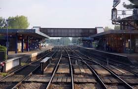
Oxford railway station is a mainline railway station, one of two[a] serving the city of Oxford, England. It is about 0.5 miles (800 m) west of the city centre, north-west of Frideswide Square and the eastern end of Botley Road. It is on the line for trains between London Paddington and Hereford via Worcester Shrub Hill. It is a starting point for fast and local trains to London Paddington and London Marylebone, and for local trains to Reading, Worcester (Shrub Hill and Foregate stations), and Banbury. It is also on the north/south Cross-Country Route from Manchester Piccadilly and Newcastle via Birmingham New Street and Reading to Southampton Central and Bournemouth. The station is managed by Great Western Railway and served by Cross-country and Chiltern Railways trains. Immediately to the north is Sheepwash Channel Railway Bridge over the Sheepwash Channel
10. Walk back into the City now crossing Hithe Bridge and cross the road carefully to enter George Street
George Street
Its western end meets Hythe Bridge Street at a crossroads with Worcester Street.
Its eastern end meets Broad Street at a crossroads with Cornmarket Street to the south and Magdalen Street to the north.
11.Walk down George Street and turn right into Cornmarket Street
Cornmarket Street is a major shopping street and pedestrian precinct in Oxford, England that runs north to south between Magdalen Street and Carfax Tower.
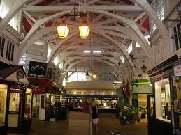
To the east of Cornmarket street is the Golden Cross arcade of small jewelry and craft shops in a historic courtyard, leading to the Covered Market. Enter the Covered Market.
The building dates to the 1770’s and has a long, varied and interesting heritage. The Market has always been an attraction for visiting tourists, providing a unique showcase for the absolute best in local crafts, food and drink. Most of our businesses are independent and with some going back generations
12.Retrace your steps back into Cornmarket street and turn right into Queen Street by Carfax Tower
Bonn Square in Oxford, England, is named after the German city of Bonn with which Oxford is twinned. It is close to the original west gate of the city of Oxford
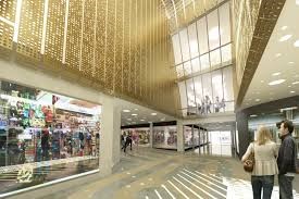
13.Enter the Westgate Shopping Centre.
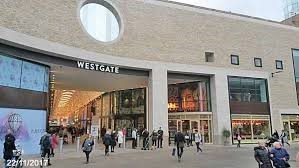
Plans for the redevelopment of the Westgate area were originally published in 2004.Over the next several years, the plan underwent several rounds of consultation and inquiry. The current plan was adopted in the early 2010s, and development permission granted in November 2014. Work on the development started in early 2015, and the original centre closed in 2016.The developer is the Westgate Oxford Alliance, a joint venture between the Crown Estate and Land Securities Group Plc.
The new centre has almost 800,000 square feet (74,000 m2) of retail, restaurant and leisure space including a new John Lewis, a rooftop dining terrace with views across Oxford’s skyline, and a five screen Curzon Cinema. According to Oxford City Council, “the £500 million redevelopment of the Westgate Centre is a key part of the regeneration of Oxford city centre, creating high quality buildings designed by world-class architects and providing more than 3,400 new full-time equivalent jobs.” The new centre reopened on 24 October 2017.
The new Westgate has features and facilities including
14.Retrace your steps to walk back up Queen street and enter through the southern door of the Clarendon Centre.
15.After leaving the centre from Queen Street, proceed past Carfax and carry on straight into the High street. Here you will notice another entrance to the covered market. Continue along the High street then turn left into Catte street.
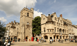
Radcliffe Camera
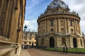
The Radcliffe Camera (Camera, meaning “room” in Latin; colloquially, “Rad Cam” or “The Camera”) is a building of Oxford University, England, designed by James Gibbs in neo-classical style and built in 1737–49 to house the Radcliffe Science Library. It is sited to the south of the Old Bodleian, north of the Church of St Mary the Virgin, and between Brasenose College to the west and All Souls College to the east. The Radcliffe Camera’s striking circularity, its position in the heart of Oxford, and its separation from other buildings make it the focal point of the University of Oxford, and as such it is almost always included in shorthand visual representations of the university.
Bodleian Library
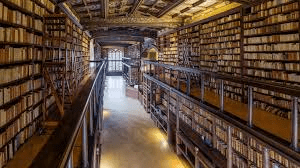
The Bodleian Library (/ˈbɒdliən, bɒdˈliːən/) is the main research library of the University of Oxford, and is one of the oldest libraries in Europe. With over 12 million items, it is the second-largest library in Britain after the British Library. Under the Legal Deposit Libraries Act 2003 it is one of six legal deposit libraries for works published in the United Kingdom, and under Irish law it is entitled to request a copy of each book published in the Republic of Ireland. Known to Oxford scholars as “Bodley” or “the Bod”, it operates principally as a reference library and, in general, documents may not be removed from the reading room
16.Turn left into Broad Street and walk towards the junction of Cornmarket street and Magdalen Street. Turn right into Magdalen Street. Walk up Magdalen Street.
Magdalen Street is a short shopping street in central Oxford, England, just north of the original north gate in the city walls. Traditionally, the name of the street is pronounced /ˈmæɡdəlɪn/ and not as the name of the College, which is always /ˈmɔːdlɪn/.
At the southern end, Magdalen Street meets Cornmarket Street continuing to the south, Broad Street to the east and George Street to the west. At the northern end it continues as St Giles’ to the north, with Beaumont Street to the west. To the west are shops. The street used to be the location of Oxford’s leading department store for many years, Elliston & Cavell. It later became a Debenhams store. On the northern corner with Beaumont Street is the Macdonald Randolph Hotel, widely considered to be Oxford’s leading hotel.
To the east is a historic church, St Mary Magdalen, originally established in Saxon times.Beyond that is Magdalen Street East and Balliol College. North of the church is the Martyrs’ Memorial, commemorating the Oxford Martyrs. Thornton’s Bookshop opened in Magdalen Street in 1835 and was located here until 1840, and again from 1853 to 1863.
17.Turn left by the Randolph Hotel into Worcester Street and follow the road past the Old Playhouse and turn left into Gloucester Green. You can finish you walk here or alternatively enter onto George Street and turn right to the railway station, where you can catch public transport to Headington Campus.
